|
On board Silurian
Most weeks April through October she is either monitoring the waters of the west coast of Scotland for whales, dolphins, and porpoises, or serving as a floating classroom for one of the many Argyll island primary and secondary schools. Read the log below to find out what Silurian and her crew have been up to each week and all about the whales, dolphins and porpoises they spot! To find out about the latest marine life sightings spotted elsewhere, click here. If you would like to send the crew an e-mail with your questions click here. Click here to view the Silurian Log archive. This blog is now located at http://www2.whaledolphintrust.co.uk/. You will be automatically redirected in 30 seconds, or you may click here. For feed subscribers, please update your feed subscriptions to http://www2.whaledolphintrust.co.uk/feeds/posts/default. # posted by HWDT @ 9:37 AM
SMRU 1-10 April 2010
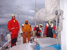
The 2010 Season has started! After some stormy days during the delivery trip from the canal (Corpac) to home port Tobermory (many thanks for the help Susie and Lewis!!), the Silurian set sail with students from the Marine Mammals MRes from the University of St Andrews. Every few days, a new group of students came onboard for an introduction in onboard fieldwork with visual surveys and acoustics. Each group had a variety of weather conditions and affiliated sea conditions, ranging from calm flat areas to very windy sailing situations. First porpoises, seals, sea eagles and otters were reported (especially in Loch Sunart), and we were able to visit some astonishing anchorages (e.g. Loch Moidart and in particular Loch Scavaig on the foot of the cuillins of Skye!). As during most surveys (if not all....), we had more acoustic porpoise detections than visual sightings, but it was good to see them again after hardly spending any time at sea during the winter. Looking forward to see the next group again in 2011!
Nienke # posted by HWDT @ 7:06 AM
End of 2009 field season
Currently, the boat is moored in the channel and we are closing down the 2009 field season. winter time will be used to analyse all data. From here, I would like to thank all volunteers who participated in the research this year. Hope you had a great time, learned something about the cetaceans and the Hebridean (marine) environment and enjoyed the beautiful landscapes and wildlife.
The 2010 season will start in April, and new updates will be posted then. If you have any question, please do not hesitate to contact me: [email protected]. Cheers, Nienke van Geel # posted by HWDT @ 3:50 AM
12th October 2009
Date: Monday 12th October
Anchorage: Tobermory Position: 56°37.176N, 06°03’.916W Distance: 30.2NM Leaving Oban, it was nice to see the water settled quite a bit and that it wasn’t as rough as yesterday evening. We headed back towards Tobermory for the end of the trip. Although very little chance, everyone kept their hopes up to see minke whales in the Sound of Mull, or other dolphin species. Unfortunately we did not see any. However, there were plenty of harbour porpoises and beautiful scenery. Also very loud ADDs (seal scarers) and engine noises from other boats were audible for most of the way. After arriving in Tobermory, we had some tea and started to clean the boat and all equipment was unloaded for the boat is going to its winter berth tomorrow. Some nice, well deserved showers while Irene was cooking a delicious dinner. The day ended with drinks in town, which lasted till the early hours ..... , with a nice surprise when arriving back on board: toast, salads and cheeses. # posted by HWDT @ 3:49 AM
11th Octover 2009
Date: Sunday 11th October
Anchorage: Oban Position: 56°24’.915N, 05°28’.577W Distance: 45.7NM After disentangling the anchor from a discarded scallop dredge (involving some acrobatics from mate Gen!) we left Bunessan and made our way through the Sound of Iona. The sun was out creating lots of beautiful rainbows - a lovely start to the day for Biodiversity Officer Nienke’s birthday! We then travelled along the Ross of Mull where there were a few harbour porpoise sightings despite quite rough conditions. The volunteers then attempted to bake a birthday cake – which was hampered by the rough sea with rather a lot ending up stuck to the oven! We then travelled up the Firth of Lorn where conditions were rather choppy so we abandoned the plans of heading to Port Appin and headed into Oban instead. Safely moored here we had some delicious salvaged birthday brownie cake and a fantastic dinner made by the birthday girl! Some of us then headed to the bright lights of Oban for a few birthday drinks! # posted by HWDT @ 3:48 AM
10th october 2009
Date: Saturday 10th October
Anchorage: Bunessan Position: 56°19’.253N, 06°15’.008W Distance: 51.9NM What can we say about today? Very rough water indeed, with a combination of rain, sea spray and gales! We saw a few seals and porpoise on route, and we got to listen in to a Brazilian warship getting attacked by pirates, which was quite amusing! (VHF radio military exercise). We also had a 3 hour recording of sonar being used in the area, from an exercise that was somewhere in the Sea of the Hebrides! At one point it was so high pitched we were unable to put the headphones on. We tried to track the sonar vessel (it was beyond our vision) however our software did not co-operate (sudden crashes the computer ruined it all.....). There was a Minke whale sighting, but alas... it was by one of the core crew members and no one else saw it, which was disappointing but at least we know they are still in the area. We managed to get quite a distance around Mull today and are hoping to get completely around it within the next few days. # posted by HWDT @ 3:45 AM
9th October 2009
Date: Friday 9th October
Anchorage: Arisaig Position: 56°54’.384N, 05°51’.536W Distance: 39.2NM Today was not one of our best days weather wise. We set out we high expectations but only had 3 to 4 sightings. Visibility was not great and we had to move to the back of the boat from the mast because it got too rough in the front. We anchored in Arisaig which was badly wanted for showers to be had. Nikki cooked up some pasta to heat us all up went down very nice. All to bed early for another fun day tomorrow..HAPPY DAYS.. many games in the evening. # posted by HWDT @ 7:48 AM
8th October 2009
Date: Thursday 8th October
Anchorage: Plockton Position: 57°20’.599N, 05°38’.2407 Distance: 44.1NM Today we were blessed with a wonderful surprise of lovely sunshine!!! The seas were also nice and calm, perfect for cetacean spotting and we were extremely fortunate with a porpoise bonanza. This perfect day allowed each of us to spend some time in the crow’s nest, definitely a highlight. With magnificent mountain views, the ability to see for miles and miles, it was certainly an exhilarating experience. These views were so incredible we could even see snow that had fallen on the highest peaks. This ideal day was topped off with the biggest group sighting yet of 15 harbour porpoises, bringing the daily tally to a total of over 40. Once anchored in a more stable position than last night, Kirsty cooked up a storm with Venison stew and veggie risotto, we then celebrated the fabulous day with a pint at the pub in Plockton. # posted by HWDT @ 7:47 AM
7th October 2009
Date: Wednesday 7th October
Anchorage: Sheildaig, Loch Torridon Position: 57°31’.576N, 05°37’.269W Distance: 61.4NM Left before crack of dawn to get to the area of the navy exercise which happened to be quite a few hours away from us. During our travel in the protection of Raasay, we saw a submarine (which disappeared in the depth), and amazing scenery. Going around the tip of Skye, the protection was gone and seas became very rough. Immediately around the corner, we picked up very loud sonar, which hurt our ears. We had to turn back to get back into the shelter again and had a nice up close and personal look on the 2 big commercial vessels passing close by and the navy vessel. Later another navy vessel was seen and again sounds were picked up from that boat. Today was a day with a record of rainbows, and luckily we kept most of the day dry. Some nice diving gannets, but unfortunately not escorted by any dolphins. After a more than 10 our survey, while seeing hardly any cetaceans we anchoraged in a beautiful spot, little but rocky and rolling though. A well deserved and fabulously tasting Dall Bhat was prepared by Rebecca, lovely! # posted by HWDT @ 2:39 AM
6th October 2009
Date: Tuesday 6th October
Anchorage: Broadford, Skye Position: 57°14’.735N, 05°54’.095W Distance: 46.7NM Calm-ish when we woke, but soon the wind was picking up, and following a disappointing weather report it was quite clear that we were not going to be able to follow the route we had previously planned!! Instead we opted to take the more sheltered route past the North of Rum and round the Southern tip of Skye, and anchored in Boardford. In going this way we missed the first planned military exercise but weather conditions at sea were too bad to pursue, but we did have our first encounter of a navy vessel! At a far, but it still dwarfed us even at a distance! On our new route we encountered many species of bird, but little marine mammals; one seal and porpoise sighting. We started to record litter sighted at sea and also creel (lobster crate buoys), which was something new to learn. We are all improving on estimating our distances, as to how far away sightings/litter and creel are. Overall not much rain today and hopefully we will be able to complete our journey around Skye and join up with NATO in the Little Minch tomorrow! # posted by HWDT @ 1:22 PM
5th October 2009
Date: Monday 5th October
Anchorage: Canna Position: 57°03.3668N, 06°29’.962W Distance: 36.9NM We woke to quite a calm sea and headed off towards the island of Canna at about 10am. Almost as soon as we left the harbour we had our first sighting - a seal! This was closely followed by several other seal sightings, both grey and common, and excitingly our first cetacean sightings of several porpoises. We were also lucky enough to see the enormous sea eagle in great proximity as it flew past the Silurian. Sea state deteriorated quickly after leaving the Sound. So instead of crossing the Minch towards Barra, it was decided to stay in reasonably calmer waters and head for anchorage in Canna instead. From Canna, we are still reasonably positioned for surveying the area where the NATO navy vessels are going to exercise (using sonar) tomorrow. Part of the crew went for a nice shore leave and enjoyed the picturesque Canna Island. Just as everyone was admiring the view over the beach it started raining badly; everyone was completely soaked within a second! Back on board, a very delicious dinner was prepared by Irene; chicken casserole and pancakes as desert! Currently we are enjoying some music and tea while writing the blog. Wondering what tomorrow will bring, besides very rough weather...... # posted by HWDT @ 1:21 PM
4th October 2009
Date: Sunday 4th October
Anchorage: Tobermory Position: 56°37.178N, 06°03’.918W Distance: 17.8NM A funny start to a very different trip. Everyone (volunteers, skipper and first mate) was supposed to take the ferry from Oban on the Saturday to start the trip on the Sunday at 10AM. Unfortunately the ferries were not operational, resulting in a group of stranded people. Luckily the first ferry on the Sunday was going so everyone managed to get onboard Silurian for the trip. Some last minute loading of the boat, general briefing and off we went surveying the Sound of Mull where the bottlenose dolphins were reported in the previous days. The weather was brilliant! Especially compared to the very windy day before. Unfortunately we didn’t spot any cetaceans but we did see some nice bird life and it was a great chance for the volunteers to practice observations and sightings protocol and to see (and hear!) the hydrophone in action. We headed back to Tobermory where first mate Genevieve cooked us a lovely dinner whilst the Skipper and Nienke went through some safety and species id presentations. # posted by HWDT @ 1:19 PM
29th September 2009
Date: Tuesday 29th September
Anchorage: Tobermory Position: 56°37’.179N, 06°03’.949W Distance travelled: 32.4NM The best was saved for last...weatherwise...partly sunny most of the day, calmer winds and seas, and no rain. Our clothing actually did dry out some for a change. The landscape was more visible and breathtaking. Again there were a few sightings of seals and porpoise, along with jellyfish at the sides of the boat, but the whales continued to elude us. The calm seas and our captain brought us safely back to Tobermory where we now clean and prepare the boat for another group’s journey. Tonight’s dinner will be another delicious creation using some of what remains on hand, and it’s already been announced there will be cheese and bacon buddies for breakfast. What a good trip this has been in spite of the weather! ........ # posted by HWDT @ 9:58 AM
28th September 2009
Date: Monday 28th September
Anchorage: Canna Position: 57°03’.299N, 06°29’.475W Distance travelled: 50.1NM Today was an occasion (the forecast said occasional rain and it never stopped). They did however get the wind right and we had a good reach all day averaging more than 7 knots. Visibility was the worst of the trip and sightings were difficult, but Arctic Skuas were seen for the first time and lots more Fulmars than other days. On arrival in Canna harbour the crew declined shore leave - they had had enough rain, and the probability of there being a pub averaged zero. Nienke volunteered to cook a superb dinner with Jane on delicious crumble pudding duty. Although photo identification pictures this trip are lacking, after dinner, we tried to identify the bottlenose dolphins seen in the previous trip (and a quick look at the killer whales sighted then as well). All together we managed to identify 3 of the 5 dolphins and we think one is a new individual not in the HWDT catalogue yet. More detailed analysis will confirm this (or not). # posted by HWDT @ 9:57 AM
27th September 2009
Date: Sunday 27th September
Anchorage: Loch Maddy, North Uist Position: 57°35’.564N, 07°09’.151W Distance: 30.2NM Von wegen Knochentrocken! Bone dry not so! Strong winds filled with rain put paid to the idyll of warm weather. However, we still have the same number of people on board as we started with. Important protocol in respect of sightings. Ian must warn the cetacean population when he is going to the Heads so that a sighting can be made by the rest of the observers. The two major sightings so far during this trip (the common dolphins and 4 harbour porpoises) have been made when he is below making himself comfortable. Comment: Ian is resisting the suggestion that he confines himself to the heads. Ancient wisdom of the day: on whatever side you stand you will get the wind directly into the face. Appendix: with the wind goes the spray. Murphy’s Law: there is no waterproof suit. Preparing dinner exciting was following the rescue actions on the VHF radio of two ground fishing vessels. At the start of the day, it was an option to go to the loch where the accident has happened. However, it was decided not to go there; a fortunate decision. Luckily all turned out to be reasonably well for stranded boat and crew. Editors note: Stornoway coastguard/Met Office was only slightly off with their forecast. Yesterday evening they brought us the very happy news that weather was going to improve to force 3-4 from the West, perfect conditions to head south on the east coast of the outer Hebrides. Unfortunately, the updated morning forecast was very disappointing with again a forecasted 5-7. To be honest, weather was as bad (if not worse) than the previous days, and we almost continuously measured force 8 from SW throughout the day.... ; even worse than the prediction.........A lot of bashing into waves, rain and wind. Chapeau for all crew on board for coping with this!!!!! # posted by HWDT @ 6:37 AM
26th September 2009
Date: Saturday 26th September
Anchorage: Procapool, Harris Position: 57°50’.653N, 06°45’.024W Distance: 42.6NM Again 5 to 7 SW. After the stars in evening the clouds were back on time in the morning but left some space for the sun to light the mountains. From the quiet loch the Silurian took us to the more interesting waters naval wise. Some gusts to Force 8 made the angle of heel reach over 45 degrees (at least that’s what it felled like, measurements on our most heeled over video only showed an angle of about 30 degrees). The route brought us from east of Skye, via the north of Skye towards the Outer Hebrides. Just before we headed into the anchor place we were starting to get excited about some dolphins who decided to check on us. They (the dolphins) may write into their diary that these life forms on board appear to have trouble staying on their feet in a 5 to 7. We logged 3 common dolphins, bearing 090, 20 metres, heading 270, playing with the boat. Unfortunately they remained only for a very short time near the boat and soon disappeared into the waves. We got to the destination without more distractions and where welcomed again by a seal. In the absence of a Pub a suggestion to a short walk around a Loch on shore. The day was then finished with a superb meal (after some chopping). We are looking forward to the 3 to 4 from the north/northwest tomorrow. # posted by HWDT @ 6:19 AM
|